
Part one of two: how the decision gets made, and who has to be in the room.
Most of the money and most of the attention in a flood warning program goes to hardware — poles, horns, gages, telemetry. The part that is most often missing is not a device. It is a written answer to a short list of questions that only matter in the hours before an emergency, when there is no incident command structure yet and no one has declared anything:
- Who is watching the river right now?
- What are they looking at?
- What reading, on what screen, means it is time to act?
- Who has the authority to act on it, and who does it when that person does not answer?
- What happens in the same minute the siren sounds?
That gap — the interval between a National Weather Service watch and an actual emergency — is where flash flood warning is won or lost, and it is the specific gap the Emergency Action Plan exists to fill. It is also, in our experience across these programs, the part that has most often been left undone.
Key takeaways
- A flood Emergency Action Plan (EAP) covers the gap between a National Weather Service watch and an actual emergency — detection through initial public warning.
- It works in five steps: detection, emergency level determination, communication, expected actions and termination.
- Three emergency levels each carry a defined public communication posture, from no siren at a watch to sirens in all impacted zones when flooding is imminent.
- The EAP does not replace the Incident Command System — it complements it.
- The test of a plan is whether the person on duty at three in the morning can follow it without calling anyone.
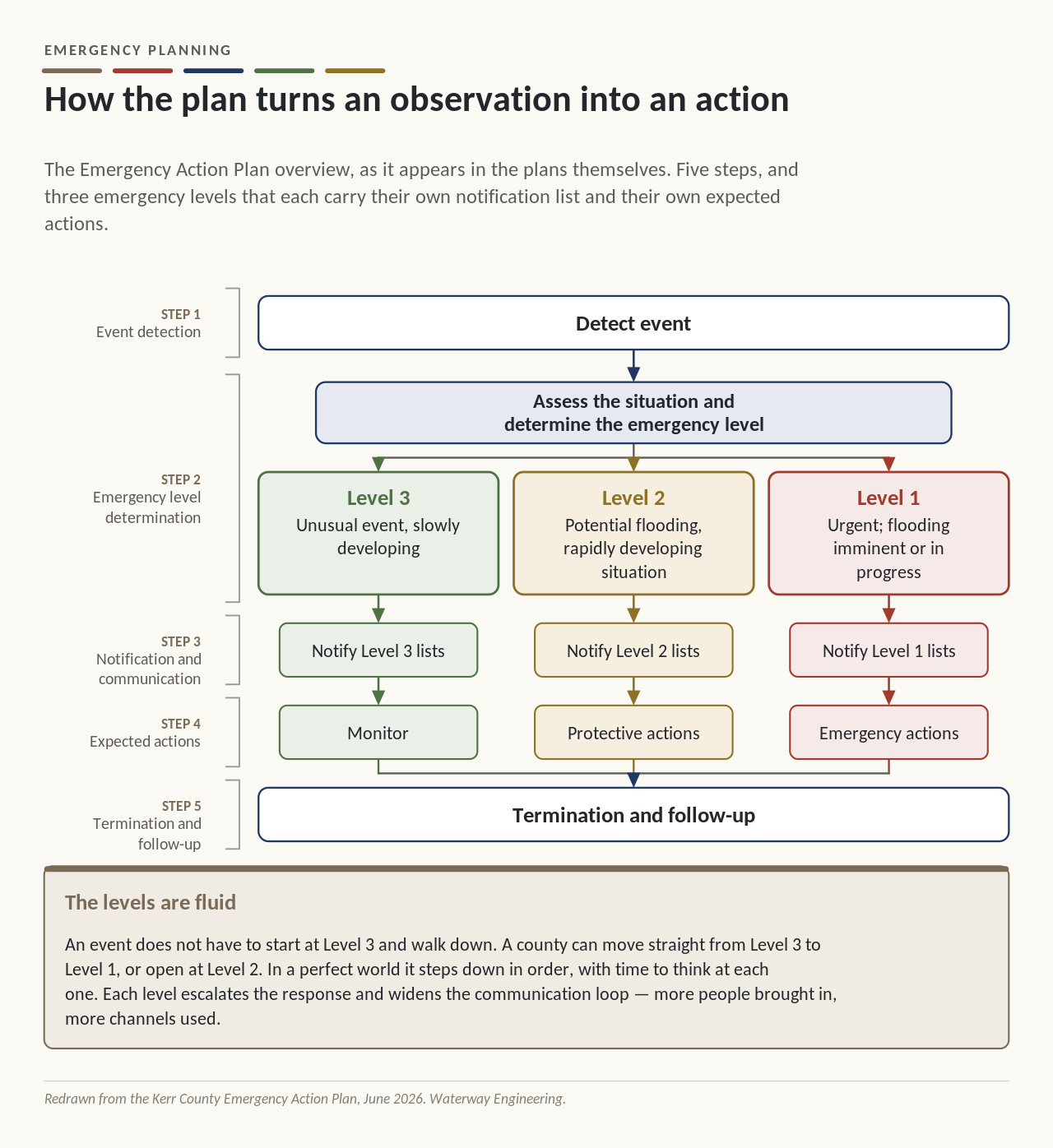
The levels are fluid. An event does not have to start at Level 3 and walk down — a county can go straight from Level 3 to Level 1, or open at Level 2. In a perfect world it steps down in order, with time to think at each one. Each level escalates the response and widens the communication loop: more people brought in, more channels used.
What the levels establish is situational awareness and a communication protocol. They are not a chain of command. The EAP does not replace the Incident Command System — it complements it. As an incident grows, command and control transitions to formal ICS operations and, if needed, the Emergency Operations Center, exactly as the county’s basic plan already provides. The EAP covers the interval before any of that exists, and then hands off.
What an EAP is, and what it is not
A flood Emergency Action Plan is a flood-specific supplement to the county’s emergency management plan, structured much like the plans already required for high-hazard dams. It does not replace the county’s emergency plan and it does not attempt to cover the whole event. It covers the front end — detection through initial public warning — because that is the part with no natural owner.
The structure we use across these counties has five steps:
- Detection. Something is observed — a forecast product, a gage reading, a rate of rise, a call from a road crew.
- Emergency level determination. The observation is classified against written criteria into one of three levels.
- Communication. The level dictates which channels are used and who is contacted.
- Expected actions. What the county does, and what the public is asked to do.
- Termination. How the event is stood down, and through which channels.
And three levels, each with a defined public communication posture:
- Level 3 — Nonemergency, slowly developing. Flash Flood Watch or equivalent.
Awareness messaging only — website and social media. No siren. - Level 2 — Potential flash flood, rapidly developing. Flash Flood Warning, rapid rise, or field reports of crossing flooding.
Mass communication to affected areas and targeted groups. Siren at the emergency manager’s discretion, by zone, where a specific corridor is threatened. - Level 1 — Urgent. Flooding imminent or in progress; life safety threatened.
All channels. Siren in all impacted zones. Wireless Emergency Alert. Mass communication. Direct contact to camps, RV parks and school districts.
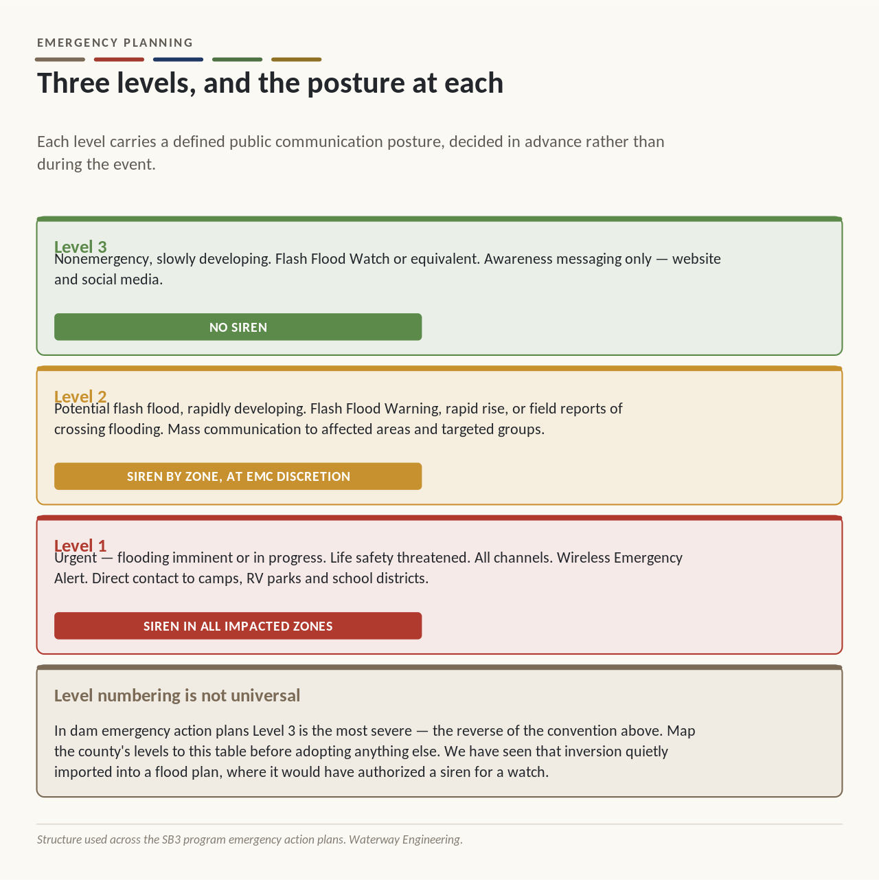
A county using different level definitions should map its levels to this table before adopting anything else. The numbering is not universal — in dam EAP conventions Level 3 is the most severe, which is the reverse of the convention above, and we have seen that inversion quietly imported into a flood plan where it would have authorized a siren for a watch.
Who is watching
This is the question that most often has no written answer, and the one where a plan earns its cost.
Name people, and name their backups. Not positions in the abstract — a named primary and a named alternate, with the understanding that the plan has to be executable at three in the morning by whoever is actually on duty rather than by whoever wrote it.
Put the authority in one place. In a survey of Missouri emergency management directors, only 37 percent actually controlled siren activation; it frequently rested with police, fire, or individual municipalities. Fragmented authority produces delay and inconsistency, and both are expensive in an event measured in tens of minutes.
Write the criteria down. Discretion exercised against written criteria is judgment. Discretion exercised against nothing is a guess that will be reviewed afterward by people who have all the time in the world.
Decide the monitoring posture in advance. Nobody watches a gage all year. What a plan can define is what raises the county’s monitoring level — a Flash Flood Watch, a seasonal threshold, a forecast product, a rainfall total — so that somebody is watching before the reading that matters arrives.
All of that is one system, and it is worth seeing whole before going any further — what the county is watching, where it lands, what it is checked against, who decides, and every channel that decision opens.
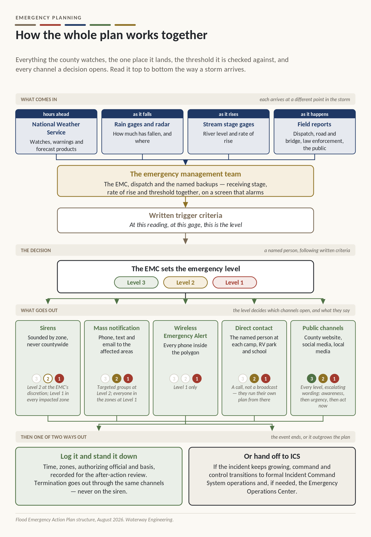
Notice what the level does at the bottom of that chart. It is not a severity label — it is the switch that decides which channels open and what each one says.
Public channels run at all three levels with escalating wording. Mass notification and direct calls to the camps start at Level 2. The siren is discretionary at Level 2 and sounds in every impacted zone at Level 1. Wireless Emergency Alert is Level 1 only.
Who the emergency manager has to talk to first
Almost none of the people an emergency manager depends on during an event report to that emergency manager. The plan is what turns a list of separate organizations into one sequence, and it is written by having the conversations in advance.
Inside the county. The judge and the commissioners, because the plan is adopted and the money is budgeted at that table. The sheriff and dispatch, because dispatch is usually where the activation actually happens and where the call comes in at three in the morning. Road and bridge, because they know which crossings go under first and they are frequently the first people to see it happening.
The cities inside the county. SB3 applies to cities as well as counties, and a siren standing inside city limits needs a named owner for operation and maintenance. That conversation is a written agreement, not a handshake, and it is far easier to have before the sirens exist than after.
The facilities that hold the people. Youth camps, RV parks, campgrounds, school districts and large employers. Each has its own staff, its own plan and its own way of moving people, and each needs a named person who receives the county’s notification and a channel that reaches them.
The people who own the data. Whoever owns the gages a county intends to trigger on — a river authority, the federal survey, a neighboring county — because a trigger that depends on somebody else’s instrument depends on their maintenance and their reporting interval too.
The neighbors and the state. The counties upstream and downstream, because water does not stop at a county line, and the state emergency management office, because the training the plan depends on runs through it.
The output of those conversations is not goodwill. It is a call list with names on it, a set of written agreements, and agreement on who does what before anybody is under pressure.
The tools follow from the plan, not the other way round
Once the plan says who decides and what they decide, it becomes obvious what they need in front of them — and that is the right order to do it in. A county that buys a dashboard first ends up with a screen nobody has been told to watch.
What falls out of a completed plan is a short list:
- Something that detects. Gages, forecast products, field reports. Covered below.
- Somewhere to see it. A dashboard that shows current stage, rate of rise and the trigger threshold on the same screen, readable on a phone, with alarming that reaches a person rather than changing a color nobody is looking at.
- Something that alerts the public. The sirens, and the mass notification system that goes out in the same minute.
- A way to reach the facilities directly. Youth camps, RV parks, school districts — one phone call converts into an on-site alerting action for dozens or hundreds of people.
- A record. Every activation logged with time, zones, authorizing official and basis. This is what an after-action review runs on, and what defends the county’s decisions afterward.
Every one of those is a procurement decision that the plan should be making, rather than the other way round.
What can actually trigger a siren
Flash flooding is harder to see coming than the hazards emergency managers are used to. A tornado and a hail core are visible on radar. Flooding is not. What radar sees is rain, and the relationship between rain falling and water rising is specific to the basin, depends on how wet the ground already is, and takes time to play out.
Why flooding is harder to see coming
Three things make the decision hard:
- The response is situation-dependent. Below a certain level the right advice is stay put. Above it, the right advice is leave. Those are opposite instructions separated by a foot of water.
- Evacuation takes time. Whatever lead time the data provides is reduced by the time it takes people to actually move — at night, in the rain, from a campground.
- Uncertainty is irreducible. Nobody can see into the future. The question is not how to eliminate the uncertainty but how much of it a county is willing to accept in exchange for lead time.
That last point is the whole shape of the problem, and it is worth drawing.
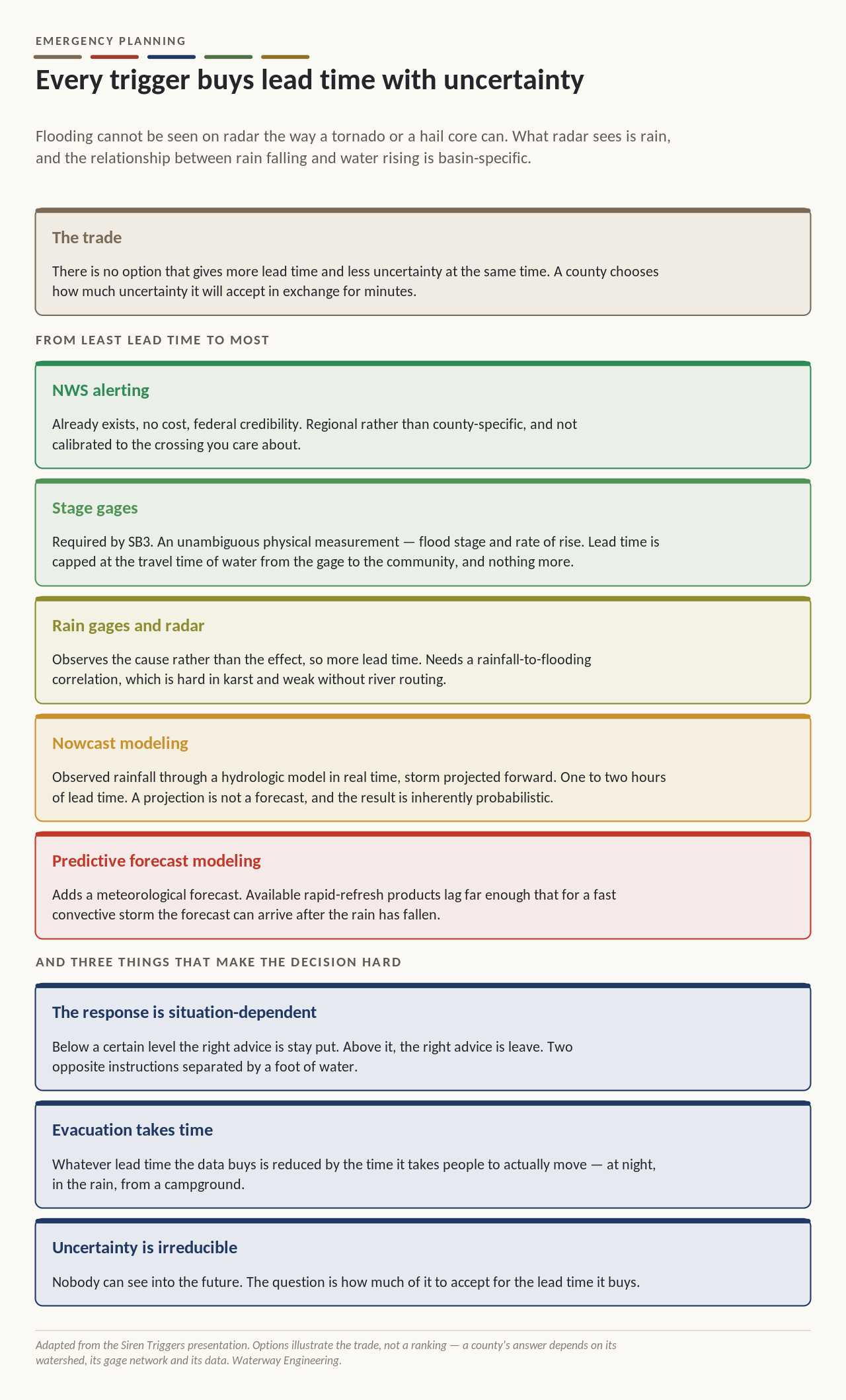
The trigger options, from least lead time to most
National Weather Service alerting. Already exists, costs nothing, and carries the credibility of a federal product. Worth remembering what it actually is: a meteorologist looking at the same data, applying judgment, and deciding to issue a warning. It is a person making a call, not an automatic output — which is a strength, and also the reason it is regional rather than county-specific and not calibrated to the particular crossing or camp the county is worried about.
Stage gages. SB3 requires at least one stream gage as an activation trigger, so this is the floor for every county. A gage gives an unambiguous, physical measurement — flood stage and rate of rise — and existing federal gages can often be used. The limit is arithmetic: lead time equals the travel time of the water from the gage to the community below it, and nothing more.
The trap there is geometric rather than technical. A gage on the main stem above town tells you nothing about the tributary that enters between that gage and the town. A community can have a perfectly good gage above it and still be blind to the creek that actually floods it.
Rainfall gages and radar. Observing the cause rather than the effect buys more lead time. The cost is analysis: correlating rainfall to flooding requires knowing the watershed’s infiltration behavior — genuinely difficult in karst country — and correlations built without river routing lose accuracy downstream.
Real-time modeling — nowcast and forecast. Both run rainfall through a hydrologic model to get a river response before it happens, and the difference between them is where the rainfall comes from.
A nowcast starts from rain that is already falling. It takes the field on radar right now and moves it forward on its current track, so the county sees the river response an hour or two ahead.
A forecast puts a weather model on the front, so the rain has not fallen yet. That is the top of the ladder, and it is where the lead time is — but forecasting convective rainfall is enormously expensive to compute, the national models run on an hourly cycle, and each run takes another hour or two to reach anyone. Part two is about what that costs in practice, and what is being built to fix it.
Where most counties are today
Where that leaves a county right now. The defensible answer in most of these counties is the bottom of the ladder: Weather Service products plus stage-gage thresholds, with the gage network designed so the thresholds mean something at the places people actually are. Rainfall correlation helps in the upper watershed where routing matters least.
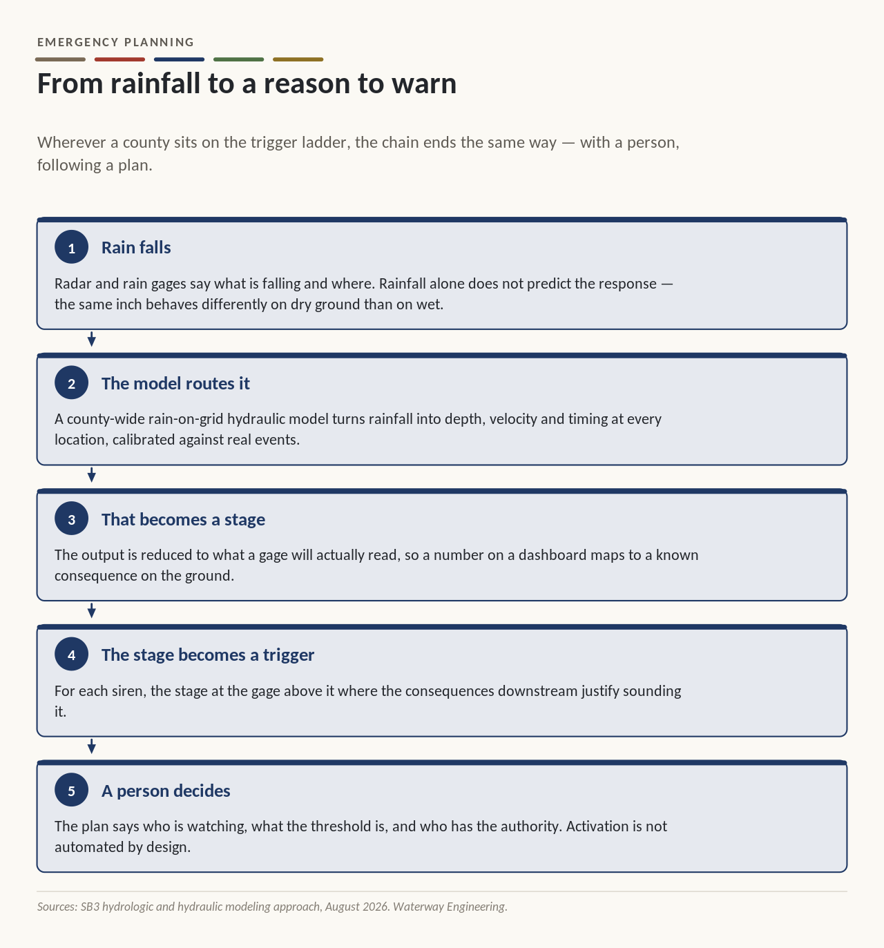
That is the honest picture of the tools available today. Part two is about the tools being built to move a county up that ladder, and what Texas is funding to get there.
Camps are participants, not audience
A camp with three hundred children is not a population to be warned. It is an organization with its own staff, its own plan and its own notification path, and it will act long before a county official arrives.
The counties furthest along write those relationships in by name: who at the camp receives the notification, on what channel, with what backup, and what the camp’s own plan does next. The same applies to RV parks, campgrounds and school districts.
And one question, asked annually, produces more life-safety improvement than any technology in this post: how would you wake everyone at two in the morning? Most facilities cannot answer it the first time they are asked.
Then it gets exercised and used
An operations plan reviewed annually and never practiced is a document. Tabletop exercises using the county’s actual tools — its real dashboard, its real activation interface, its real call list — are what turn it into a capability. The guide recommends exercises rather than requiring them.
Occasionally the weather runs the exercise instead. Waterway developed the flood Emergency Action Plan for Kerr County, and it was put to work during the flood event of July 16, 2026. The plan performed as written: the level was determined against the criteria, the notifications went out to the lists the plan names, and the people who needed to act knew in advance that it was theirs to do.
That is the whole return on this kind of work, and it is not visible until the night it is needed.
The test of an Emergency Action Plan is not whether it is complete. It is whether the person on duty at three in the morning can follow it without calling anyone.
Frequently asked questions
What is a flood Emergency Action Plan?
A flood Emergency Action Plan is a flood-specific supplement to the county’s emergency management plan, structured much like the plans already required for high-hazard dams. It covers the front end — detection through initial public warning — because that is the part with no natural owner.
What are the three emergency levels?
Level 3 is nonemergency and slowly developing, with awareness messaging only and no siren. Level 2 is a potential flash flood, with mass communication to affected areas and the siren at the emergency manager’s discretion, by zone. Level 1 is urgent, with all channels, sirens in all impacted zones, Wireless Emergency Alert and direct contact to camps, RV parks and school districts.
Does an Emergency Action Plan replace the Incident Command System?
No. The EAP does not replace the Incident Command System — it complements it. As an incident grows, command and control transitions to formal ICS operations and, if needed, the Emergency Operations Center.
What can trigger a flood warning siren?
The options range from National Weather Service alerting and stage gages, which offer the least lead time and the least uncertainty, to rainfall gages and radar, nowcast modeling and predictive forecast modeling, which offer more lead time with more uncertainty. SB3 requires at least one stream gage as an activation trigger.
Part 2 Coming Soon: Building the Tool That Makes the Call. Why the national forecast models were never built for this, and what SB5 is funding instead.
Waterway Engineering is prime engineer for SB3 outdoor warning siren programs across nineteen Texas counties.